Restaurant nearby Kumata Hut
Bulgaria
Restaurant nearby Kumata Hut
Kumata Hut
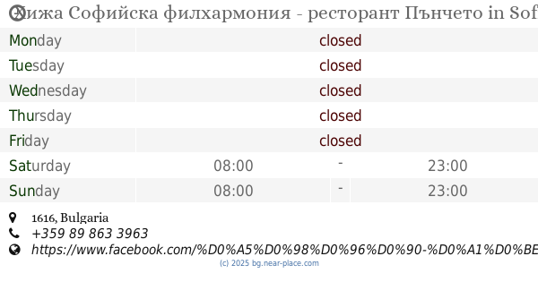
1616 Sofia, Bulgaria
contacts phone
:
+359
Latitude:
42.594433
, Longitude:
23.2506108
larger map & directions
read more
nearest Restaurant
14 m
VITOSHA: h.Kumata
Restaurant
read more
1.183 km
Skiing Vetrovala
Restaurant
read more
2.007 km
Бистро Златни Мостове
Restaurant
read more
2.011 km
Hotel-Restaurant Golden Bridges
Restaurant
read more
2.369 km
Хижа Софийска филхармония - ресторант Пънчето
Restaurant
read more
3.889 km
Moten
Sofia, Vitosha, Mestnost Aleko
Restaurant
read more
4.263 km
restaurant Bai Krusty
Restaurant
read more
5.629 km
Владайска гозба
ulitsa "Professor Ivan Shishmanov" 33, Vladaya
Restaurant
read more
5.695 km
Kamenelo
ул.Офелиите 12, Vladaya
Restaurant
read more
5.746 km
При Ева
ulitsa "Yankino usoe" 2, Vladaya
Restaurant
read more
5.816 km
Ресторант Океан
ulitsa "Professor Ivan Shishmanov" 8, Vladaya
Restaurant
read more
5.933 km
BOMI - P
Владая, Реката 18
Restaurant
read more
6.09 km
Ресторант Охрид
Nartsis №17A, София
Restaurant
read more
6.994 km
Kelari Greek Cuisine
bulevard "Cherni vrah" 226 1415, Sofia
Restaurant
read more
7.024 km
Kelari
bulevard "Cherni vrah" 220, Sofia
Restaurant
read more
9.673 km
Клуб-ресторант Интерленд
ulitsa "Koloman" 6, Sofia
Restaurant
read more
10.74 km
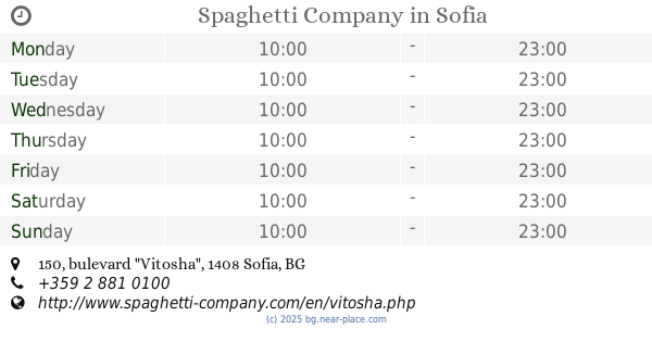
Spaghetti Company
bulevard "Vitosha" 150, Sofia
Restaurant
read more
11.41 km
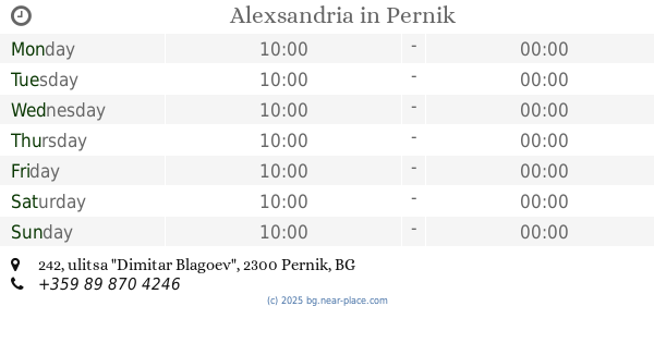
Alexsandria
ulitsa "Dimitar Blagoev" 242, Pernik
Restaurant
read more
12.196 km
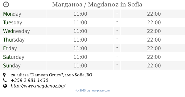
Магданоз / Magdanoz
ulitsa "Damyan Gruev" 28, Sofia
Restaurant
read more
12.258 km
Kapanche
ulitsa "Lyulin" 45, Malo Buchino
Restaurant
read more
12.336 km
Традиционна Баница - Handmade Banitza
ulitsa "Solunska" 17-15, Sofia
Restaurant
read more
12.418 km
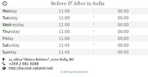
Before & After
ulitsa "Hristo Belchev" 12, Sofia
Restaurant
read more
13.059 km
Pizza Lab
[email protected]
, Boulevard "Tsarigradsko shose" 115, Sofia
Restaurant
read more
13.261 km
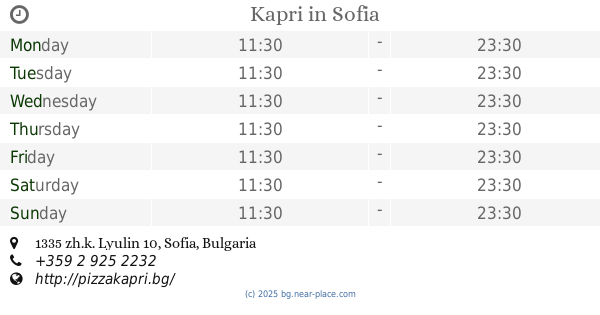
Kapri
Sofia
Restaurant
read more
15.771 km
Скара при Капитана
kv. Vasil Levski, 1517
Restaurant
read more
📑
all categories
Accounting
Administrative area level 1
Administrative area level 2
Airport
Amusement park
Aquarium
Art gallery
Atm
Bakery
Bank
Bar
Beauty salon
Bicycle store
Book store
Bowling alley
Bus station
Cafe
Campground
Car dealer
Car rental
Car repair
Car wash
Casino
Cemetery
Church
City hall
Clothing store
Colloquial area
Convenience store
Courthouse
Dentist
Department store
Doctor
Electrician
Electronics store
Embassy
Establishment
Finance
Fire station
Florist
Food
Funeral home
Furniture store
Gas station
General contractor
Grocery or supermarket
Gym
Hair care
Hardware store
Health
Home goods store
Hospital
Insurance agency
Jewelry store
Laundry
Lawyer
Library
Light rail station
Liquor store
Local government office
Locality
Locksmith
Lodging
Meal delivery
Meal takeaway
Mosque
Movie rental
Movie theater
Moving company
Museum
Natural feature
Neighborhood
Night club
Painter
Park
Parking
Pet store
Pharmacy
Physiotherapist
Place of worship
Plumber
Point of interest
Police
Political
Post office
Premise
Real estate agency
Restaurant
Roofing contractor
Route
School
Shoe store
Shopping mall
Spa
Stadium
Storage
Store
Subpremise
Subway station
Supermarket
Synagogue
Taxi stand
Train station
Transit station
Travel agency
University
Veterinary care
Zoo
administrative area level 3
sublocality level 1
↑