Supermarket nearby T Market
Bulgaria
Supermarket nearby T Market
T Market
15, ulitsa "Dorostol", 1373, Sofia, BG Bułgaria
contacts phone
:
+359
Latitude:
42.6970656
, Longitude:
23.276174
larger map & directions
read more
nearest Supermarket
359 m
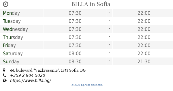
BILLA
bulevard "Vazkresenie" 66, Sofia
Supermarket
read more
721 m
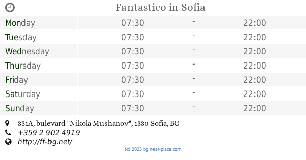
Fantastico
bulevard "Nikola Mushanov" 331А, Sofia
Supermarket
read more
841 m
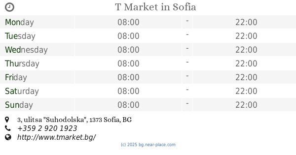
T Market
ulitsa "Suhodolska" 3, Sofia
Supermarket
read more
921 m
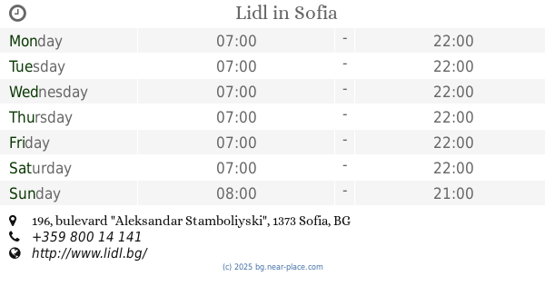
Lidl
bulevard "Aleksandar Stamboliyski" 196, Sofia
Supermarket
read more
931 m
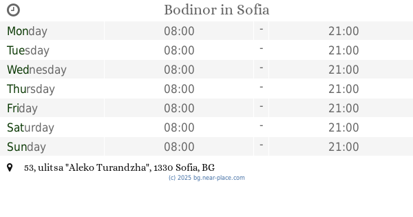
Bodinor
ulitsa "Aleko Turandzha" 53, Sofia
Supermarket
read more
937 m
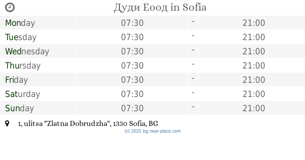
Дуди Еоод
ulitsa "Zlatna Dobrudzha" 1, Sofia
Supermarket
read more
1.19 km
Fantastico
ulitsa "Hashove" 4, Sofia
Supermarket
read more
1.19 km
Fantastico F39
ulitsa "Hashove" 4, Sofia
Supermarket
read more
1.375 km
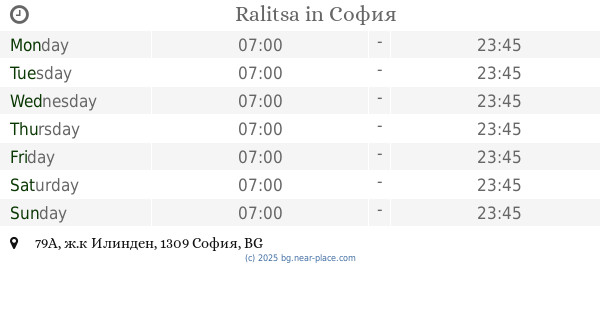
Ralitsa
79-А,, ж.к Илинден 79А, София
Supermarket
read more
1.52 km
Berezka
bulevard "Tsaritsa Yoanna" 15, Sofia
Supermarket
read more
1.569 km
Hippoland
Булевард Царица Йоана № 15, Мега МОЛ, Sofia
Supermarket
read more
1.59 km
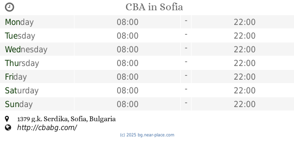
CBA
Sofia
Supermarket
read more
1.647 km
Магазин 345
310 а, ж.к. Света Троица 310А, Sofia
Supermarket
read more
1.65 km
KAM Market
ulitsa "Tsar Simeon" 310, Sofia
Supermarket
read more
1.707 km
Kaufland
ulitsa "Kukuryak" 3, Sofia
Supermarket
read more
1.853 km
supermarket RECORD
ulitsa "Gyueshevo" 12, Sofia
Supermarket
read more
1.952 km
Billa
ulitsa "Tsar Ivan Aleksandar" 27, Sofia
Supermarket
read more
1.956 km
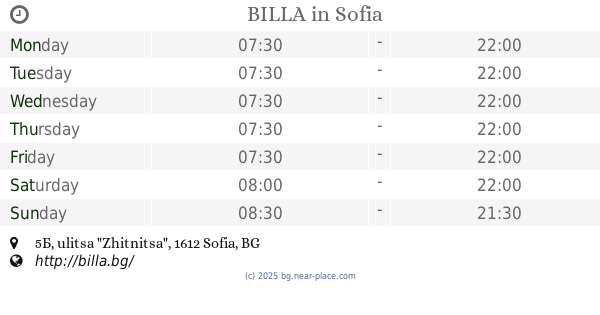
BILLA
ulitsa "Zhitnitsa" 5Б, Sofia
Supermarket
read more
2.022 km
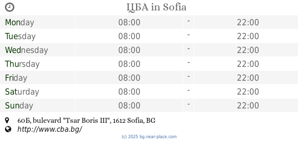
ЦБА
bulevard "Tsar Boris III" 60Б, Sofia
Supermarket
read more
2.063 km
Kaufland
бул. „д-р Петър Дертлиев“ 56, София
Supermarket
read more
2.065 km
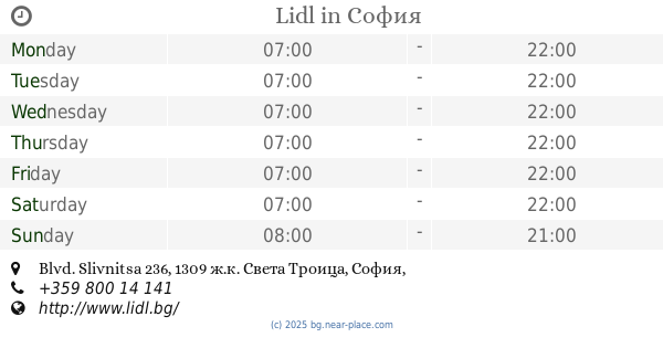
Lidl
Blvd. Slivnitsa 236, София
Supermarket
read more
2.136 km
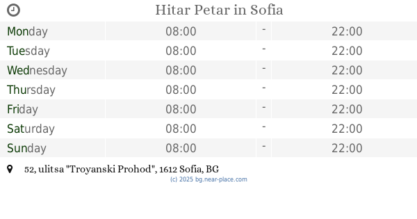
Hitar Petar
ulitsa "Troyanski Prohod" 52, Sofia
Supermarket
read more
2.14 km
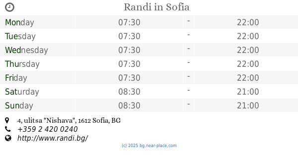
Randi
ulitsa "Nishava" 4, Sofia
Supermarket
read more
2.288 km
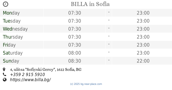
BILLA
ulitsa "Sofiyski Geroy" 4, Sofia
Supermarket
read more
2.624 km
Detelini (Burov)
g.k Hipodruma 122-E, Sofia
Supermarket
read more
📑
all categories
Accounting
Administrative area level 1
Administrative area level 2
Airport
Amusement park
Aquarium
Art gallery
Atm
Bakery
Bank
Bar
Beauty salon
Bicycle store
Book store
Bowling alley
Bus station
Cafe
Campground
Car dealer
Car rental
Car repair
Car wash
Casino
Cemetery
Church
City hall
Clothing store
Colloquial area
Convenience store
Courthouse
Dentist
Department store
Doctor
Electrician
Electronics store
Embassy
Establishment
Finance
Fire station
Florist
Food
Funeral home
Furniture store
Gas station
General contractor
Grocery or supermarket
Gym
Hair care
Hardware store
Health
Home goods store
Hospital
Insurance agency
Jewelry store
Laundry
Lawyer
Library
Light rail station
Liquor store
Local government office
Locality
Locksmith
Lodging
Meal delivery
Meal takeaway
Mosque
Movie rental
Movie theater
Moving company
Museum
Natural feature
Neighborhood
Night club
Painter
Park
Parking
Pet store
Pharmacy
Physiotherapist
Place of worship
Plumber
Point of interest
Police
Political
Post office
Premise
Real estate agency
Restaurant
Roofing contractor
Route
School
Shoe store
Shopping mall
Spa
Stadium
Storage
Store
Subpremise
Subway station
Supermarket
Synagogue
Taxi stand
Train station
Transit station
Travel agency
University
Veterinary care
Zoo
administrative area level 3
sublocality level 1
↑