Park nearby Парк Славия
Bulgaria
Park nearby Парк Славия
Парк Славия
1618 Sofia, Bulgaria
contacts phone
:
+359
Latitude:
42.6757421
, Longitude:
23.2727389
larger map & directions
read more
nearest Park
286 m
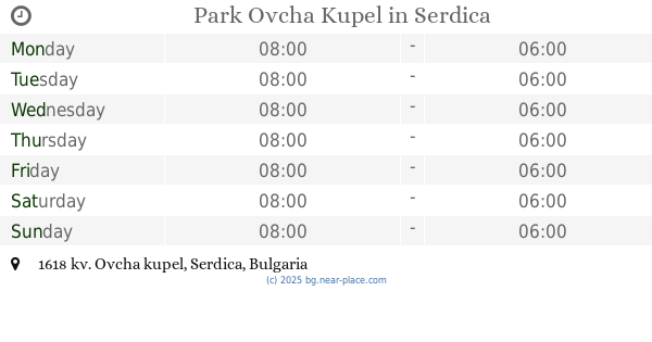
Park Ovcha Kupel
Sofia
Park
read more
726 m
Кучешка градинка
Sofia
Park
read more
1.365 km
Roundabout Pushkin
boulevard „Aleksandar S. Pushkin“ 13, Sofia
Park
read more
1.64 km
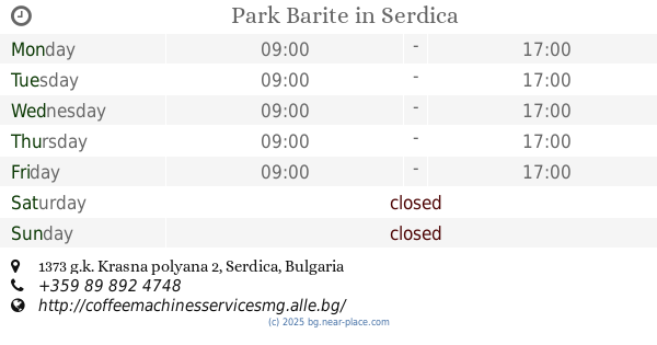
Park Barite
Sofia
Park
read more
2.48 km
Boyana Residency
Sofia
Park
read more
2.563 km
Rayska Gradina
bulevard "Tsar Boris III" 254, Sofia
Park
read more
2.875 km
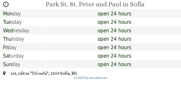
Park St. St. Peter and Paul
ulitsa "Tri ushi" 141, Sofia
Park
read more
2.905 km
Park Gorna Banya
Sofia
Park
read more
3.163 km
Suho Ezero Garden
ulitsa "Konstantin Irechek" 20, Sofia
Park
Point of interest
Establishment
read more
3.364 km
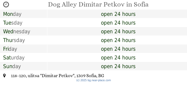
Dog Alley Dimitar Petkov
ulitsa "Dimitar Petkov" 118-120, Sofia
Park
read more
3.414 km
Градината на доброто
Sofia
Park
Point of interest
Establishment
read more
3.451 km
Кнежевска гора
Sofia
Park
read more
3.471 km
Park „Europe“
Unnamed Road, 1309, Sofia
Park
read more
3.5 km
Park „Vazrazhdane“
Sofia
Park
Point of interest
Establishment
read more
3.547 km
Park Vuzrajdane
Sofia
Park
Premise
Point of interest
Establishment
read more
3.942 km
Park National Palace of Culture
bulevard "Vitosha", Sofia
Park
read more
4 km
Park Auto
bulevard "Vitosha" 72, Sofia
Park
Point of interest
Establishment
read more
4.12 km
Градина „Баня Лозенец”
ulitsa "Kaliakra" 25-27, Sofia
Park
read more
4.143 km
Dog park
ulitsa "Pirotska" 85, Sofia
Park
Point of interest
Establishment
read more
4.201 km
garden Revival
bulevard "Aleksandar Stamboliyski", Sofia
Park
read more
4.616 km
„Рила“
ulitsa "Tsar Kaloyan" 1, Sofia
Park
read more
4.713 km
пл. „Самарско знаме“
София
Park
Point of interest
Establishment
read more
4.715 km
Bаunishora
ulitsa "Razcvetna" 15, Sofia
Park
read more
5.098 km
Crystal Garden
Sofia
Park
read more
5.185 km
градина Майчин дом
градина "Майчин дом", Sofia
Park
read more
📑
all categories
Accounting
Administrative area level 1
Administrative area level 2
Airport
Amusement park
Aquarium
Art gallery
Atm
Bakery
Bank
Bar
Beauty salon
Bicycle store
Book store
Bowling alley
Bus station
Cafe
Campground
Car dealer
Car rental
Car repair
Car wash
Casino
Cemetery
Church
City hall
Clothing store
Colloquial area
Convenience store
Courthouse
Dentist
Department store
Doctor
Electrician
Electronics store
Embassy
Establishment
Finance
Fire station
Florist
Food
Funeral home
Furniture store
Gas station
General contractor
Grocery or supermarket
Gym
Hair care
Hardware store
Health
Home goods store
Hospital
Insurance agency
Jewelry store
Laundry
Lawyer
Library
Light rail station
Liquor store
Local government office
Locality
Locksmith
Lodging
Meal delivery
Meal takeaway
Mosque
Movie rental
Movie theater
Moving company
Museum
Natural feature
Neighborhood
Night club
Painter
Park
Parking
Pet store
Pharmacy
Physiotherapist
Place of worship
Plumber
Point of interest
Police
Political
Post office
Premise
Real estate agency
Restaurant
Roofing contractor
Route
School
Shoe store
Shopping mall
Spa
Stadium
Storage
Store
Subpremise
Subway station
Supermarket
Synagogue
Taxi stand
Train station
Transit station
Travel agency
University
Veterinary care
Zoo
administrative area level 3
sublocality level 1
↑