Gas station nearby Бензиностанция Ойл
Bulgaria
Gas station nearby Бензиностанция Ойл
Бензиностанция Ойл
4, ulitsa "Nikola Chenishevski", 2303, Pernik, BG Bulgaria
contacts phone
:
+359
Latitude:
42.6147672
, Longitude:
23.0856521
larger map & directions
read more
nearest Gas station
667 m
Mid
bulevard "Yuriy Gagarin" 2, Pernik
Gas station
read more
932 m
Бензиностанция Форс
ulitsa "Mladen Stoyanov" 39, Pernik
Gas station
read more
1.256 km
ЕКО Бензиностанция
булевард „Скоростна магистрала“, Pernik
Gas station
read more
1.62 km
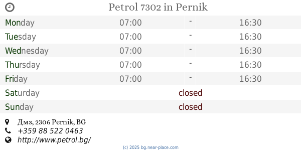
Petrol 7302
Дмз, Pernik
Gas station
read more
1.77 km
Shell 9003 Перник Струма
bulevard "Yuriy Gagarin", Pernik
Gas station
read more
1.775 km
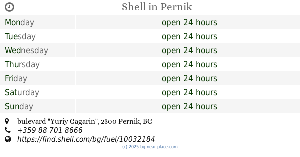
Shell
bulevard "Yuriy Gagarin", Pernik
Gas station
read more
1.89 km
Паулър Тиим
Pernik
Gas station
read more
2.361 km
An-Mari
bulevard "Yuriy Gagarin" 46Б, Pernik
Gas station
read more
2.642 km
Lukoil B068
bulevard "Yuriy Gagarin", Pernik
Gas station
read more
2.645 km
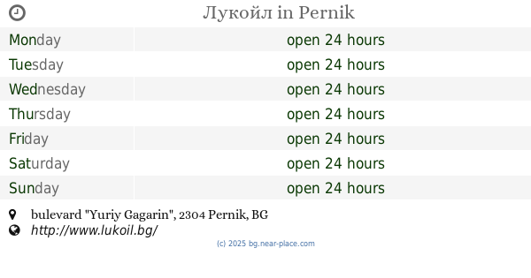
Лукойл
bulevard "Yuriy Gagarin", Pernik
Gas station
read more
3.986 km
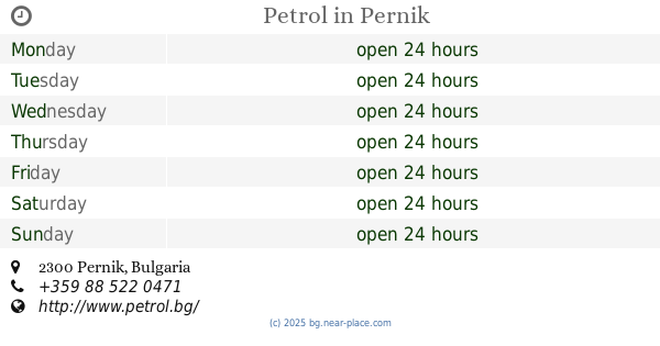
Petrol
Pernik
Gas station
read more
4.796 km
Газстанция Стемо газ
На Главния Път, Dragichevo
Gas station
read more
4.856 km
Cyclon
на главния път, Dragichevo
Gas station
read more
5.099 km
Shell
E871 I-1/e79 Road, Dragichevo
Gas station
read more
7.515 km
Лукойл
E871, Vladaya
Gas station
read more
7.762 km
AVIA Vladaia
E871, Vladaya
Gas station
read more
7.784 km
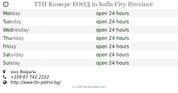
ТТН Комерс ЕООД
Gas station
read more
11.626 km
Avanti Gaz
София, бул. Цар Борис III 424
Gas station
read more
14.994 km
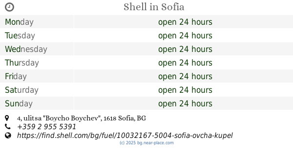
Shell
ulitsa "Boycho Boychev" 4, Sofia
Gas station
read more
17.972 km
Shell
bul. Pancho Vladigerov, Sofia
Gas station
read more
18.284 km
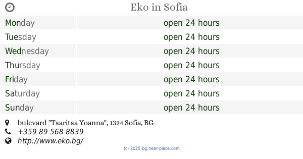
Eko
bulevard "Tsaritsa Yoanna", Sofia
Gas station
read more
18.649 km
Ilda-R
g.k. Lyulin 9 910A, Sofia
Gas station
read more
18.931 km
Magendo
Sofia, Evropa Blvd 138
Gas station
read more
19.151 km
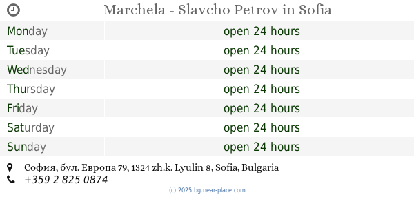
Marchela - Slavcho Petrov
София, бул. Европа 79
Gas station
read more
20.526 km
Petrol
ulitsa "Akademik Dmitriy Lihachov" 2, Sofia
Gas station
read more
📑
all categories
Accounting
Administrative area level 1
Administrative area level 2
Airport
Amusement park
Aquarium
Art gallery
Atm
Bakery
Bank
Bar
Beauty salon
Bicycle store
Book store
Bowling alley
Bus station
Cafe
Campground
Car dealer
Car rental
Car repair
Car wash
Casino
Cemetery
Church
City hall
Clothing store
Colloquial area
Convenience store
Courthouse
Dentist
Department store
Doctor
Electrician
Electronics store
Embassy
Establishment
Finance
Fire station
Florist
Food
Funeral home
Furniture store
Gas station
General contractor
Grocery or supermarket
Gym
Hair care
Hardware store
Health
Home goods store
Hospital
Insurance agency
Jewelry store
Laundry
Lawyer
Library
Light rail station
Liquor store
Local government office
Locality
Locksmith
Lodging
Meal delivery
Meal takeaway
Mosque
Movie rental
Movie theater
Moving company
Museum
Natural feature
Neighborhood
Night club
Painter
Park
Parking
Pet store
Pharmacy
Physiotherapist
Place of worship
Plumber
Point of interest
Police
Political
Post office
Premise
Real estate agency
Restaurant
Roofing contractor
Route
School
Shoe store
Shopping mall
Spa
Stadium
Storage
Store
Subpremise
Subway station
Supermarket
Synagogue
Taxi stand
Train station
Transit station
Travel agency
University
Veterinary care
Zoo
administrative area level 3
sublocality level 1
↑