Bar nearby Дартс Републик
Bulgaria
Bar nearby Дартс Републик
Дартс Републик
1379, ulitsa "Sini vir", 1379, Sofia, BG Bulgaria
contacts phone
:
+359 88 696 1119
website:
darts-republic.bg
Latitude:
42.6927835
, Longitude:
23.2941374
larger map & directions
read more
nearest Bar
841 m
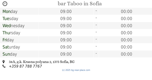
bar Taboo
g.k. Krasna polyana 2 38A, Sofia
Bar
read more
854 m
Birariya Bolyarka
Sofia, bul. Totleben 85-87
Bar
read more
938 m
So Bar
ulitsa "Sofiyski Geroy" 3, Sofia
Bar
read more
1.016 km
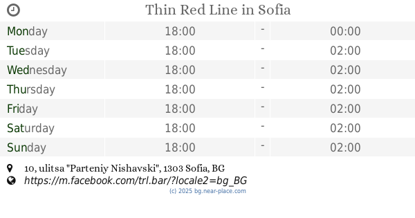
Thin Red Line
ulitsa "Parteniy Nishavski" 10, Sofia
Bar
Point of interest
Establishment
read more
1.053 km
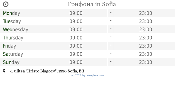
Грифона
ulitsa "Hristo Blagoev" 6, Sofia
Bar
read more
1.164 km
Piano Bar Rodina
София, ул. Тотлебен 8
Bar
read more
1.395 km
Voodoo Bar
ulitsa "Pirotska" 96, Sofia
Bar
read more
1.525 km
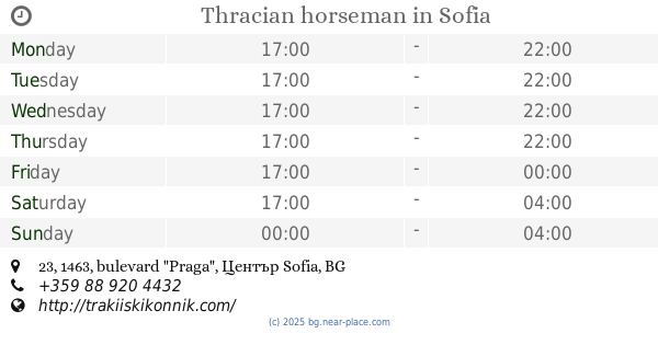
Thracian horseman
bulevard "Praga" 23, 1463, Sofia
Bar
read more
1.574 km
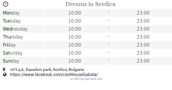
Dreams
Sofia
Bar
read more
1.594 km
Irish Bar
ulitsa "Tundzha" 27, Sofia
Bar
read more
1.604 km
Клуб Шапките
1606, ulitsa "Lajos Kossuth" 9А, Sofia
Bar
read more
1.638 km
Piano Bar B29
София, ул. Владайска 29
Bar
read more
1.697 km
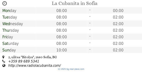
La Cubanita
ulitsa "Bitolya" 2, Sofia
Bar
read more
1.72 km
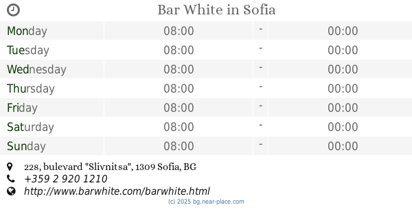
Bar White
bulevard "Slivnitsa" 228, Sofia
Bar
read more
1.75 km
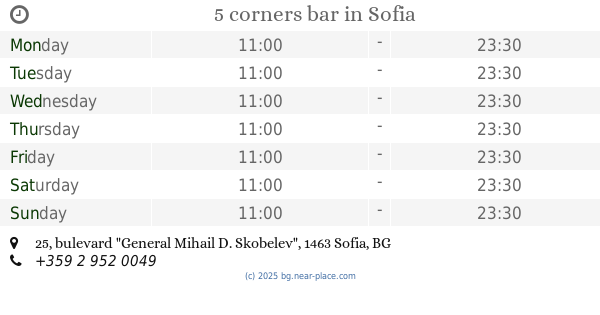
5 corners bar
bulevard "General Mihail D. Skobelev" 25, Sofia
Bar
read more
1.82 km
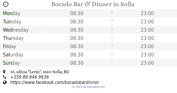
Bocado Bar & Dinner
ulitsa "Lerin" 55, Sofia
Bar
read more
1.912 km
Bar NRG
ulitsa "Knyaz Boris I" 80, Sofia
Bar
read more
1.926 km
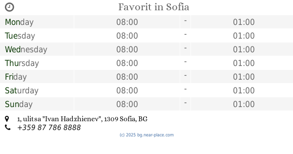
Favorit
ulitsa "Ivan Hadzhienev" 1, Sofia
Bar
read more
1.952 km
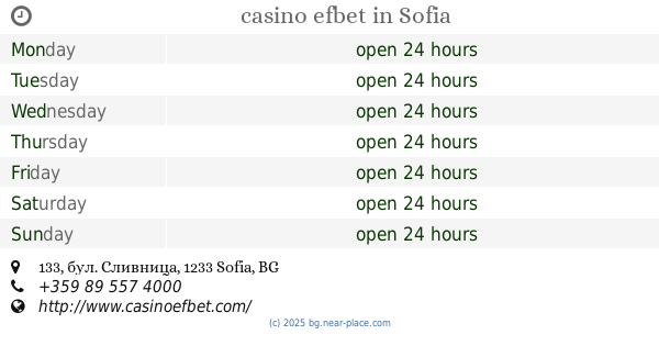
casino efbet
бул. Сливница 133, Sofia
Casino
Bar
Point of interest
Establishment
read more
1.956 km
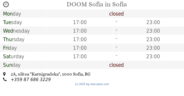
DOOM Sofia
ulitsa "Karnigradska" 2А, Sofia
Bar
read more
1.988 km
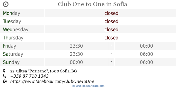
Club One to One
ulitsa "Pozitano" 22, Sofia
Bar
Point of interest
Establishment
read more
2.006 km
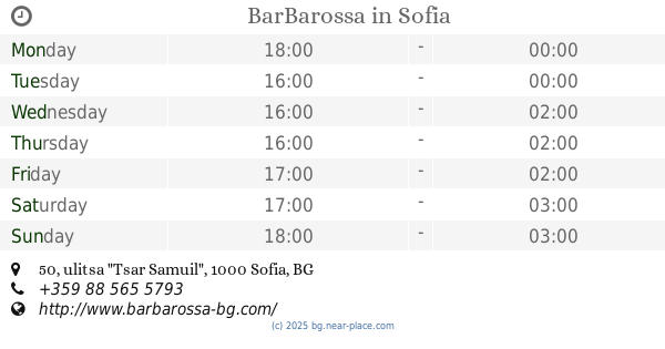
BarBarossa
ulitsa "Tsar Samuil" 50, Sofia
Bar
read more
2.012 km
NOVA KETARING
ulitsa "Kraishte" 33, Sofia
Bar
read more
2.255 km
Cashterminal
ulitsa "Sv. Sveti Kiril I Metodiy" 89, Sofia
Bar
read more
2.326 km
Rock Bar Rock It
bulevard "Petko Karavelov" 5, Sofia
Bar
read more
📑
all categories
Accounting
Administrative area level 1
Administrative area level 2
Airport
Amusement park
Aquarium
Art gallery
Atm
Bakery
Bank
Bar
Beauty salon
Bicycle store
Book store
Bowling alley
Bus station
Cafe
Campground
Car dealer
Car rental
Car repair
Car wash
Casino
Cemetery
Church
City hall
Clothing store
Colloquial area
Convenience store
Courthouse
Dentist
Department store
Doctor
Electrician
Electronics store
Embassy
Establishment
Finance
Fire station
Florist
Food
Funeral home
Furniture store
Gas station
General contractor
Grocery or supermarket
Gym
Hair care
Hardware store
Health
Home goods store
Hospital
Insurance agency
Jewelry store
Laundry
Lawyer
Library
Light rail station
Liquor store
Local government office
Locality
Locksmith
Lodging
Meal delivery
Meal takeaway
Mosque
Movie rental
Movie theater
Moving company
Museum
Natural feature
Neighborhood
Night club
Painter
Park
Parking
Pet store
Pharmacy
Physiotherapist
Place of worship
Plumber
Point of interest
Police
Political
Post office
Premise
Real estate agency
Restaurant
Roofing contractor
Route
School
Shoe store
Shopping mall
Spa
Stadium
Storage
Store
Subpremise
Subway station
Supermarket
Synagogue
Taxi stand
Train station
Transit station
Travel agency
University
Veterinary care
Zoo
administrative area level 3
sublocality level 1
↑